
TALLAHASSEE, Fla. (WCTV) – [9/26 2:30 p.m.] At 2:25 p.m., the National Hurricane Center confirmed Helene has strengthened into a major hurricane.
Helene has maximum sustained winds of 120 mph and a minimum pressure of 959 mb.
[9/26 11 a.m.] As of the 11:00 am Thursday advisory from the National Hurricane Center, Hurricane Helene had sustained winds of 105mph and was moving towards the north-northeast at 14mph.

Hurricane Helene is forecast to make landfall overnight Thursday as a category 3 hurricane. It will be a fast-moving storm and leave South Georgia before sunrise on Friday.
Preparations by the coast should be completed before 2pm. Preparations inland should be complete before 6pm.
Here are some forecast notes:
Peak Storm Surge Potential: Potential for 15-20 feet from Carrabelle to the Suwannee River. Potential for 10-15 feet from Apalachicola to Carrabelle.
Sustained coastal winds around and just east of the center: 75 – 100+ mph. Gusts can be slightly higher.
Sustained inland winds around and just east of the center: 50 – 75+ mph. Gusts can be slightly higher.
Rainfall totals: 3 to 7 more inches on top of what we have already received.
[9/26 8 a.m.] As of the 8:00 am Thursday advisory from the National Hurricane Center, Hurricane Helene had sustained winds of 100mph and was moving towards the north-northeast at 12mph. Hurricane Helene is now a category 2 hurricane.

The official forecast calls for landfall late tonight, possibly closer to midnight, somewhere between Franklin and Taylor County. Tropical storm-force winds will be felt well outside of the forecast cone, but the most damaging hurricane-force winds will be centered closely around the core of the hurricane.
The intensity forecast (how strong it will be) has come down a bit, so that is at least a little encouraging. It is still forecast to make landfall as a major category-three hurricane. It will still be a fast-moving hurricane, making landfall late Thursday night and moving out of South Georgia by 3:00 am Friday.
The potential peak storm surge is 15-20ft above sea level at the coast. You MUST evacuate this morning if you live on the coast in a surge-prone area. Damaging hurricane-force winds will accompany the core of the hurricane. Power outages will be widespread.
[9/25 6 p.m.] As of the 5:00 pm Wednesday advisory from the National Hurricane Center, Hurricane Helene had sustained winds of 85mph and was moving towards the north at 12mph. Helene crossed over from the Caribbean to the Gulf of Mexico Wednesday afternoon.
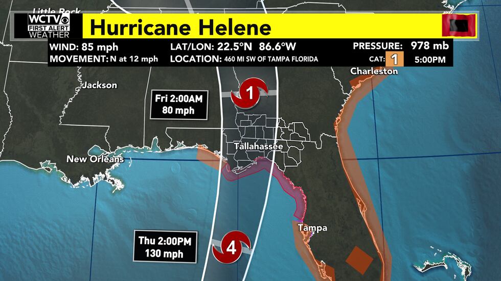
The forecast track brings a relatively fast-moving, major category-four hurricane into the Big Bend of Florida Thursday night. It is then forecast to quickly move inland through South Georgia. The storm will have exited our area well before sunrise on Friday.
Landfall will occur somewhere between Franklin and Taylor County. Try not to focus too much on the middle of the forecast cone, as a landfall is possible anywhere within that cone. The entire Big Bend and South Georgia are under hurricane warnings, so we are prepared for hurricane conditions all across our area.
A fast-moving hurricane like Helene will not drop as much rain as a slow-moving hurricane would, but it will be able to hold onto its strength a bit further inland than a slow-moving storm would.
In Thursday morning’s update, we can narrow down who will be getting the worst of the hurricane, and what to expect on a local level in communities across the Big Bend and South Georgia. As of 6pm Wednesday, Hurricane Helene was about 400 miles from the coast of the Florida Big Bend. That leaves plenty of room for subtle changes that will impact the final landing spot of the hurricane.

Preparations and evacuations must be complete by early Thursday afternoon. After that, tropical-storm-force winds will be arriving.
[9/25 2 p.m.] Josh Green provided a live update on the status of Helene. Watch it back here.
[9/25 11 a.m.] Helene was upgraded to a category 1 hurricane as of the 11am Wednesday advisory from the National Hurricane Center. As of that advisory, Helene had sustained winds of 80mph and was moving towards the NNW at 10mph.

A landfall is possible anywhere from Franklin to Taylor County. We can fine-tune a landing spot and those very local impacts by Thursday morning.
If you are under a hurricane warning, you should be prepared for hurricane conditions. If you are under a tropical storm warning, you should be prepared for tropical storm conditions. If you are under a storm surge warning, you should evacuate if you are able to. Continue to listen to local officials regarding evacuation orders.
The rest of today is a great day to make those preparations or to evacuate. Tropical storm-force winds are expected to arrive in the Big Bend by midday on Thursday. Preparations should be complete by that time.
[9/24 5:30 p.m.] The National Hurricane Center released an update on Tropical Storm Helene at 5 p.m., and the forecast was relatively unchanged.
Helene has maximum sustained winds of 50 mph and a minimum pressure of 995 mb.
Tropical Storm Helene is located roughly 150 miles south of the western tip of Cuba and moving west/northwest at 12 mph.
(story continues below)
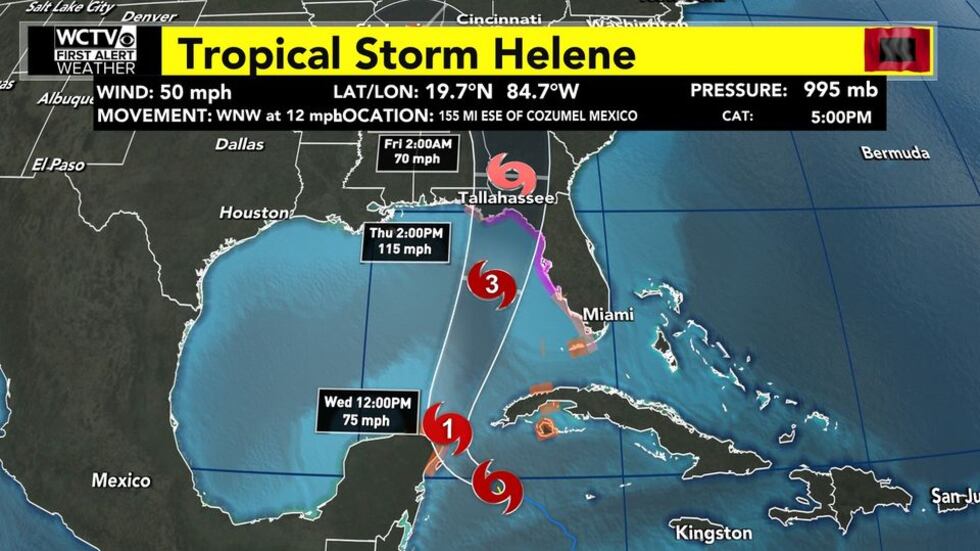
The NHC is still forecasting Helene to strengthen into a hurricane by Wednesday morning near Cancun and rapidly intensify into a major hurricane by Thursday morning in the Gulf of Mexico.
The forecast still shows Helene making landfall Thursday night as a Category 3 storm with winds of 115 mph in the Big Bend. Could we see changes to the left and right in future cones? Absolutely, so stay weather aware and keep up with our updates. However, models have been consistent in the current forecast.
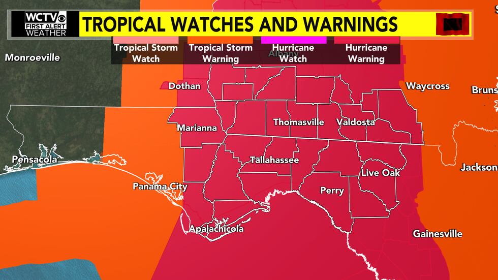
A Hurricane Warning is now in place for most of our Florida counties (dark red). A Hurricane Watch now extends into South Georgia and near the I-75 corridor (bright pink). A Tropical Storm Warning is in effect for Calhoun and Jackson counties, while a Tropical Storm Watch is in place for Seminole and Miller counties.

A Storm Surge Warning is in effect for coastal Franklin, Wakulla, Jefferson and coastal Taylor counties.

The storm surge forecast has not changed, and we could still see significant storm surge for parts of our coastline, especially to the right of the center. For coastal Franklin County, the NHC is forecasting 5-10 feet of storm surge. For coastal Wakulla, coastal Jefferson and coastal Taylor counties, the current forecast calls for 10-15 feet of storm surge. It is important to note, this does NOT mean every location along the coast will see 10-15 feet of storm surge. However, it means some spots could see storm surge values this high in the worst case scenario.

In terms of rainfall, we are tracking a soaking rain across the Big Bend and South Georgia. Because of the fast forward speed of Helene, we are not anticipating widespread, double-digit rainfall totals like we had with Hurricane Debby. However, because of recent rain and saturated ground, flooding will still be a concern for some. We are expecting 4-8″ of rain across the region, with locally higher amounts near the coast. A Flood Watch is in place through Friday morning.

We could also see a few rotating thunderstorms, mainly along and east of the center of circulation. The Storm Prediction Center has outlined our eastern counties (from Perry to Valdosta and points east) in a Level 2 Slight risk of severe weather for Thursday. With the current track, a few spin-up tornadoes cannot be ruled out, mainly along and east of I-75.

I know this can be information overload, but it is important to understand the different threats. We do not want anyone to panic, but it is important to take this threat seriously and prepare accordingly. Be sure to pay attention to future updates and get your weather information from a reliable source. Also, check in with your local emergency officials as more information rolls in.
[9/24 5 p.m.] National Hurricane Center places the majority of the Big Bend under Hurricane Warning. See all weather alerts here.
[9/24 3:40 p.m.] Meteorologist Cameron Aaron provided a live update on Tropical Storm Helene during First Alert Daily. You can watch here or in the video below.
[9/24 11 a.m.] The 11 a.m. advisory is out from the National Hurricane Center, and we officially have Tropical Storm Helene.

Helene is located around 170 miles south/southeast of the western tip of Cuba. The maximum winds are sitting at 45 mph, and the minimum pressure is 1000 mb.
In terms of alerts, we have many to discuss. A Storm Surge Watch is in place for coastal Franklin, coastal Wakulla, coastal Jefferson and coastal Taylor counties.

For coastal Franklin, the National Hurricane Center is forecasting 5-10 feet of storm surge. For everyone else in the Storm Surge Watch, the current forecast calls for 10-15 feet of storm surge.
A Hurricane Watch is in place for most of the Big Bend. Because of the quick speed of this system, we should see the Hurricane Watch extended into parts of South Georgia. With the current track, hurricane-force winds (at least 74 mph) will be possible for most of our region.

Because this system is moving so quickly, rain totals should not be as high as Debby. However, with the saturated ground across our region, flooding will still be an issue for some. We are anticipating 4-8″ of rain for most, with locally higher amounts. A Flood Watch runs through Friday morning for everyone.
With the nice weather on Tuesday, now is the time to prepare. Confidence continues to increase that we see a major hurricane make landfall in the Big Bend on Thursday. Remember, don’t panic but be prepared. Listen to your local emergency officials and evacuate if you are told to do so.
We will update this blog as more information rolls in.
[9/23 5 p.m.] As of 5 p.m., the National Hurricane Center has Potential Tropical Cyclone Nine around 315 miles southeast of the western tip of Cuba. It is a “Potential Tropical Cyclone” because it lacks tropical characteristics at this point.
However, the National Hurricane Center is expecting this system to get its act together by Tuesday. The NHC is forecasting Tropical Storm Helene to develop by Tuesday morning with winds of 40 mph.
(story continues below)

The 5 p.m. track was slightly shifted to the west. The NHC is forecasting this system to split the difference between Cuba and Cancun as a hurricane early Wednesday. Next, it is expected to move into the southeastern Gulf of Mexico and continue strengthening.
The NHC is now forecasting a low-end Category 3 hurricane by Thursday afternoon in the Gulf of Mexico. Remember, the initial forecast was 110 mph (Category 2). The new update has peak winds at 115 mph, and this increase of five miles per hour qualifies for major hurricane status.
Confidence is increasing that we will see a hurricane make landfall in Florida by Thursday afternoon/evening, but the exact location is still not set in stone. The current cone has landfall in the Big Bend, but this cone can (and likely will) change in the coming days. It is not time to panic or worry, but this is a tropical threat to take seriously.
Go ahead and use the dry, mostly sunny weather on Monday and Tuesday to review your hurricane preparedness plan.
Again, more changes in the future track and intensity are likely, so it is very important to keep up with a reliable source as more data rolls in. We will keep you updated throughout the week. You can download our free WCTV First Alert Weather app for more.
[9/23 4:15 p.m.] Meteorologist Cameron Aaron provided a live update on Potential Tropical Cyclone Nine during First Alert Daily. You can watch here.
[9/23 1 p.m.] All eyes are on Potential Tropical Cyclone Nine in the Caribbean. As of 11 a.m. Monday, the National Hurricane Center is forecasting this system to become Tropical Storm Helene on Tuesday.
The current forecast also calls for Helene to strengthen into a Category 2 Hurricane with winds of 110 mph by Thursday morning. For context, Category 3 status begins at 111 mph.
The current cone has PTC Nine moving into the Gulf of Mexico by Wednesday morning. This will likely be a fast-moving system. The NHC is forecasting this system to make landfall along the Florida Gulf Coast by Thursday evening and we are drying out by Friday morning. Because of the fast motion, that should help keep rainfall totals at a manageable level, but some areas are already very saturated and do not need the rain.
Keep in mind, we are still about three days away from this system moving onshore. During this timeframe, we will likely see more shifts and jumps in our model data for track and intensity.
While a shift of 50-100 miles may not sound significant, it can cause big changes in what you see at your home. If your town or city is near or east of the center, impacts will be greater. If you end up on the western side of the system, impacts will be less.
It can be frustrating, but the final track and intensity are not set in stone. We are expecting more changes in the coming days as more data rolls in. Until then, go ahead and look over your hurricane plan and start preparing for potential impacts. For our region, the worst of the weather looks to be Thursday evening and night.
We will keep you updated throughout the week. Have the free WCTV First Alert Weather app for future updates.
[9/23 11 a.m.] With the 11 a.m. advisory, the National Hurricane Center has designated Potential Tropical Cyclone Nine in the Caribbean.
The current forecast shows PTC Nine strengthening into a tropical storm by Tuesday morning and a Category 2 Hurricane by Thursday evening.
The current track shows landfall along the Florida Gulf Coast, but there still remains uncertainty in the final track and intensity.
Be sure to stay tuned for future updates.

To stay updated on all the latest forecasts and weather, follow WCTV First Alert Weather on Facebook and X (Twitter).
Click here to see all the latest weather headlines and here to view the First Alert Radar. Receive push alerts and watch the latest forecast anytime on the free WCTV First Alert Weather app. Click here to download it now.
Interested in becoming a WCTV First Alert Weather Watcher? Click here to join the team!
Copyright 2024 WCTV. All rights reserved.