It certainly wasn’t a blockbuster storm, but many areas picked up light accumulations. See the totals here.
AUSTIN, Texas — While it wasn’t a major storm, most of the KVUE area managed to pick up at least a dusting of snow Monday night into Tuesday morning. In some locations, there were even totals over 1 inch.
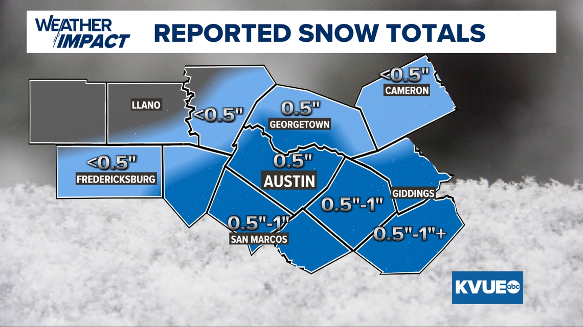
Below, you will find a generalized map of how much snow fell, and also a list of all of the accumulation reports by county.
These numbers include the total accumulation of snow, sleet and graupel. It wasn’t all fluffy snowflakes and was instead a mixed bag of wintry precipitation.

Travis County:
- 7 miles N of Austin: 0.8 inches
- 9.7 miles NNW of Austin: 0.8 inches
- 3 miles SSW of Jollyville: 0.7 inches
- 0.6 miles NE of Tanglewood Forest: 0.5 inches
- 1.4 miles SSW of Leander: 0.5 inches
- 9.8 miles WSW of Austin: 0.5 inches
- 4 miles W of Tanglewood Forest: 0.5 inches
- 2.9 miles E of Tanglewood Forest: 0.5 inches
- 0.4 miles ESE of Lakeway: 0.5 inches
- 2.0 miles NNE of Lago Vista: 0.5 inches
- 2 miles SSE of Sunset Valley: 0.5 inches
- 1 mile WNW of Onion Creek: 0.5 inches
- 5.6 miles WSW of Austin: 0.4 inches
- 2.3 miles SW of Anderson Mill: 0.4 inches
- 3 miles NW of Tanglewood Forest: 0.4 inches
- 3 miles NNW of Austin: 0.4 inches
- Austin Bergstrom Internation Airport: 0.3 inches
- 4 miles WNW of Leander: 0.2 inches
- 4 miles NNE of Austin: Trace
- Lakeway: Trace
- 2 miles SSE of Sunset Valley: Trace
- Bee Cave: Trace
- 2 miles N of Sunset Valley: Trace
- 5 miles SSE of Jollyville: Trace
Williamson County:
- Taylor: 1 inch
- 6.7 miles NNW of Georgetown: 0.9 inches
- 0.3 miles NNW of Round Rock: 0.3 inches
- Leander: 0.1 inches
- 1.2 miles N of Liberty Hill: Trace
Bastrop County:
- 6.5 miles W of Bastrop: 0.6 inches
- 2.2 miles WNW of Bastrop: 0.5 inches
- 0.8 miles WSW of Bastrop: 0.4 inches
- 0.8 WNW of McDade : 0.4 inches
Blanco County:
- 7.9 miles WNW of Johnson City: 0.8 inches
Burnet County:
- 4.4 miles NW of Spicewood: 0.3 inches
- Marble Falls: Trace
- 3.9 miles ENE of Burnet: Trace
- Burnet: Trace
- 2.3 miles W of Burnet: Trace
Caldwell County:
- 5.2 miles SSE of Lockhart: 1.2 inches
- 1.0 mile SSW of Luling: 0.5 inches
- Luling: 0.5 inches
Fayette County:
- La Grange: 1 inch
- 3.5 miles ENE of La Grange: 0.7 inches
- 0.2 miles NNW of La Grange: 0.5 inches
Hays County:
- 3.6 miles ENE of Wimberley: 1 inch
- 0.5 miles SSW of Woodcreek: 0.8 inches
- 2 miles NNW of Henley: 0.7 inches
- 5.3 miles WNW of Wimberley: 0.6 inches
- San Marcos: 0.6 inches
- 3.9 miles WNW of Buda: 0.6 inches
- 2.8 miles WSW of San Marcos: 0.5 inches
Lee County
- Dime Box: 0.5 inches
Llano County:
- 1.9 miles WSW of Buchanan Dam: Trace