AUSTIN, Texas — It’s that time of year, when high temperatures, dry soil and high winds combine to create fire weather concerns across Central Texas.
Geography, structure density and other factors can contribute to just how much danger a given area is at risk of. To help Austin residents have a better idea of their neighborhood’s risk, the Austin Fire Department’s (AFD) Wildfire Division has an interactive map demonstrating the Wildland Urban Interface (WUI), where wildlands and communities meet or intermix.
Wildlands are defined as areas of 10 acres or greater that are covered with vegetation, and AFD says wildlands cover 59% of Travis County and 36% of Austin. Roughly 49% of the structures in Austin and 65% of the structures in Travis County are in the WUI.
AFD also has a Community Wildfire Risk map, where you can type in your address to see your area’s risk, which fire department services your neighborhood and more.
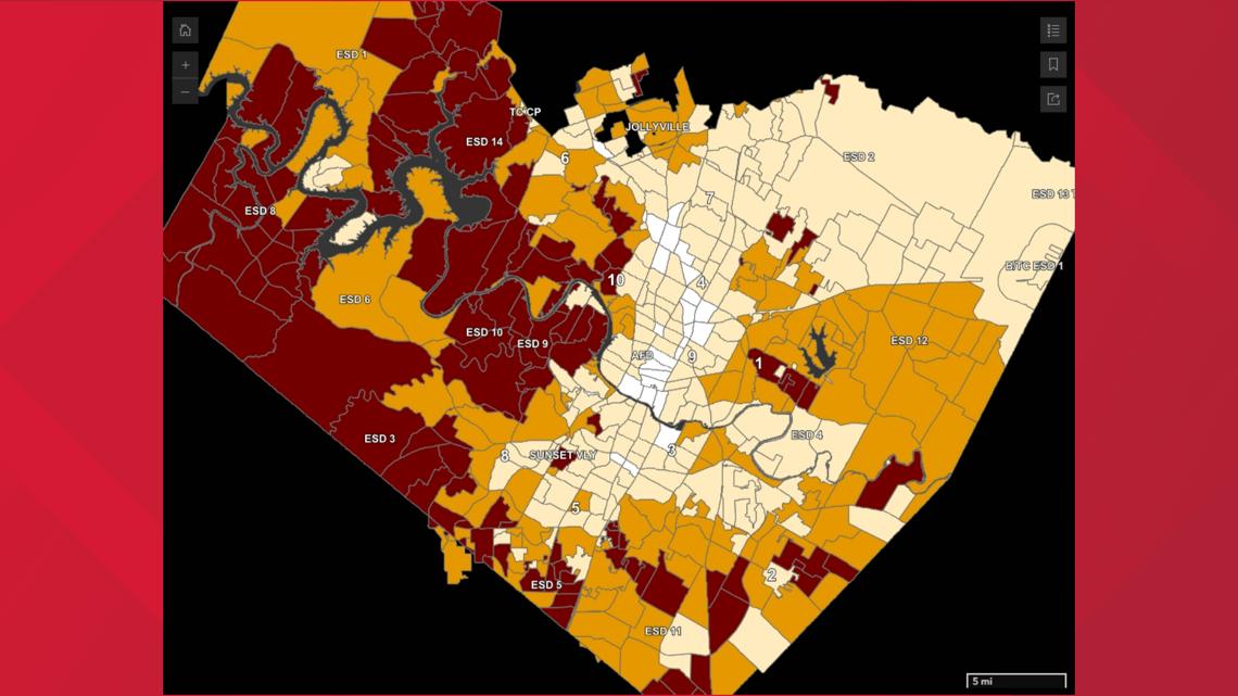
Below is a snapshot of the Community Wildfire Risk map. White represents areas with “low” fire danger, beige represents “moderate,” yellow represents “elevated” and red represents “high.” Black would represent “highest.”
As you can see, while Austin City Council districts 3, 4, 7 and 9 have a fairly moderate risk, other parts of town – like districts 1, 6 and 10 – have a much higher risk.

Could the Wildfire Urban Interface be expanded?
According to a report from KUT, Austin’s current WUI map was drawn in 2015 and city leaders are expected to greatly expand it soon.
KUT reports that Austin City Council members are scheduled to discuss updating rules surrounding the WUI later this month. The changes would put 71% of the city’s land parcels in a zone vulnerable to burning if a wildfire breaks out.
Austin recently ranked fifth in the U.S. on a list of cities with the highest number of homes at risk of being impacted by wildfires. The four cities ranked higher than Austin are all in California.
What’s being done to protect homes?
Back in 2020, KUT reports that Austin adopted its first set of building rules designed to protect homes from wildfires. Those regulations, which vary depending on where a homeowner lives, require builders of new and remodeled homes to “harden” them against fire damage by doing things like building with fire-resistant materials, installing windows that are less likely to crack in extreme heat and installing vents in a way that embers can’t fly inside.
However, according to the report, builders have said the additional requirements could add to the cost of construction, which could then be passed on to homebuyers. Experts also say the risk of wildfire damage to someone’s home can raise the cost of insurance.